# Does anyone know Who was drilling these
**URL:** https://www.mineralrightsforum.com/t/does-anyone-know-who-was-drilling-these/61193
**Category:** Grady County, OK
**Created:** [March 23, 2021, 1:18pm UTC](https://www.mineralrightsforum.com/t/does-anyone-know-who-was-drilling-these/61193 "2021-03-23T13:18:35Z")
**Posts on this page:** 9
**Page:** 1
### Author:  [@Stephcarp](https://www.mineralrightsforum.com/u/Stephcarp)
#### Post date: [March 23, 2021, 1:18pm UTC](https://www.mineralrightsforum.com/t/does-anyone-know-who-was-drilling-these/61193/1 "2021-03-23T13:18:35Z")
24-04N-06W 20-04N-05W I’m trying to find out what oil companies were working these from 2005-2017. How can I find this out? There is a 10+ year lapse in my grandfather’s royalty payments. (Settling his estate) Any help would be appreciated.
---
### Author:  [@M\_Barnes](https://www.mineralrightsforum.com/u/M_Barnes)
#### Post date: [March 23, 2021, 2:17pm UTC](https://www.mineralrightsforum.com/t/does-anyone-know-who-was-drilling-these/61193/2 "2021-03-23T14:17:57Z")
> **[Test](https://imaging.occ.ok.gov/imaging/OGWellRecords.aspx)**
Look up by the surface location to get a list of the wells. You would only get paid on wells where his minerals were in the spacing unit. You do need to pay attention to the KEM Ranch 1-24-25XH horizontal well. It will be the most valuable in 24-4N-6W. Marathon Oil Company. The Form 1002A is the completion report. Form 1073 is an operator change. 1003 is plug and abandon.
for 20-04N-05W, there are a good number of horizontal wells that are spud in 20 but may not have production in 20. Dawkins 1-20H is probably your most important.
For productive wells, look them up on the Gross Production site (OK tax site). [https://otcportal.tax.ok.gov/gpx/gp\_displayPublicPUNListSearchDownload.php](https://otcportal.tax.ok.gov/gpx/gp_displayPublicPUNListSearchDownload.php)
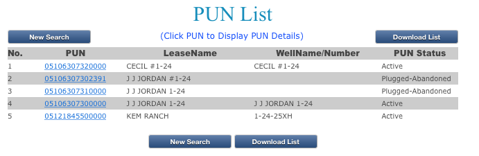 Here is section 24 above. 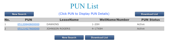Not sure about Johnson Rogers as it is mostly in 17&8.
---
### Author:  [@M\_Barnes](https://www.mineralrightsforum.com/u/M_Barnes)
#### Post date: [March 23, 2021, 2:18pm UTC](https://www.mineralrightsforum.com/t/does-anyone-know-who-was-drilling-these/61193/3 "2021-03-23T14:18:26Z")
Check the unclaimed funds at the OK state Treasurer’s office.
---
### Author:  [@Stephcarp](https://www.mineralrightsforum.com/u/Stephcarp)
#### Post date: [March 23, 2021, 7:28pm UTC](https://www.mineralrightsforum.com/t/does-anyone-know-who-was-drilling-these/61193/4 "2021-03-23T19:28:00Z")
Thank you! I will go research it. As for the unclaimed, we got that covered. That’s what brought it to my attention.
---
### Author:  [@M\_Barnes](https://www.mineralrightsforum.com/u/M_Barnes)
#### Post date: [March 23, 2021, 8:41pm UTC](https://www.mineralrightsforum.com/t/does-anyone-know-who-was-drilling-these/61193/5 "2021-03-23T20:41:04Z")
Get that KEM Ranch settled because they have five more horizontal wells planned. You may get offers to buy since the increased density case is out.
---
### Author:  [@Stephcarp](https://www.mineralrightsforum.com/u/Stephcarp)
#### Post date: [March 23, 2021, 11:04pm UTC](https://www.mineralrightsforum.com/t/does-anyone-know-who-was-drilling-these/61193/6 "2021-03-23T23:04:48Z")
Is there any way we can have a private message?
---
### Author:  [@Rick\_Rademaker](https://www.mineralrightsforum.com/u/Rick_Rademaker)
#### Post date: [March 24, 2021, 5:55pm UTC](https://www.mineralrightsforum.com/t/does-anyone-know-who-was-drilling-these/61193/7 "2021-03-24T17:55:59Z")
Martha, Concerning the Kem Ranch, are you referring to the Warwick-Jupiter Increase Well Density application, Cause No. 202001277. Thanks
---
### Author:  [@M\_Barnes](https://www.mineralrightsforum.com/u/M_Barnes)
#### Post date: [March 25, 2021, 7:15pm UTC](https://www.mineralrightsforum.com/t/does-anyone-know-who-was-drilling-these/61193/8 "2021-03-25T19:15:12Z")
Marathon has increased density cases in 24 & 25 202100135 (24) and 202100136 (25). Scroll down on 36 to see the maps of the predicted wells. Has the Gulfport wells in the surrounding sections.
Other working interest owners sometimes file increased density in order to get the operator off ground zero and get moving.
---
### Author:  [@system](https://www.mineralrightsforum.com/u/system)
#### Post date: [June 21, 2021, 1:18pm UTC](https://www.mineralrightsforum.com/t/does-anyone-know-who-was-drilling-these/61193/9 "2021-06-21T13:18:46Z")
This topic was automatically closed after 90 days. New replies are no longer allowed.