# Copy Land Survey
**URL:** https://www.mineralrightsforum.com/t/copy-land-survey/71517
**Category:** Law & Legal
**Created:** [July 10, 2023, 1:41am UTC](https://www.mineralrightsforum.com/t/copy-land-survey/71517 "2023-07-10T01:41:22Z")
**Posts on this page:** 12
**Page:** 1
### Author:  [@marisol1245](https://www.mineralrightsforum.com/u/marisol1245)
#### Post date: [July 10, 2023, 1:41am UTC](https://www.mineralrightsforum.com/t/copy-land-survey/71517/1 "2023-07-10T01:41:22Z")
Own land BLK 7 Sec 14 need info H&GN RY Co Survey or where would I be able to find a copy of the survey?
---
### Author:  [@Clint\_Liles](https://www.mineralrightsforum.com/u/Clint_Liles)
#### Post date: [July 10, 2023, 1:57am UTC](https://www.mineralrightsforum.com/t/copy-land-survey/71517/3 "2023-07-10T01:57:59Z")
marisol1245…I’m thinking Reeves County in the State of Texas could be the location of the minerals in question? Am I correct?
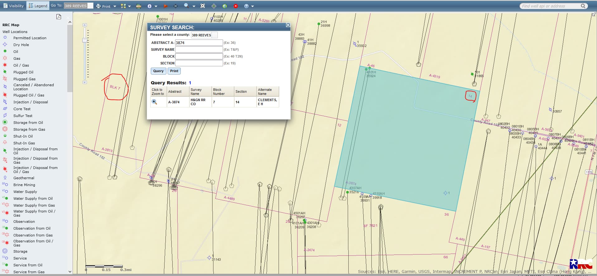CLICK ON MAP TO ENLARGE
---
### Author:  [@marisol1245](https://www.mineralrightsforum.com/u/marisol1245)
#### Post date: [July 10, 2023, 10:19am UTC](https://www.mineralrightsforum.com/t/copy-land-survey/71517/4 "2023-07-10T10:19:20Z")
Yes it is. Would you happen to know who to contact to get a copy of the survey?
---
### Author:  [@marisol1245](https://www.mineralrightsforum.com/u/marisol1245)
#### Post date: [July 10, 2023, 10:24am UTC](https://www.mineralrightsforum.com/t/copy-land-survey/71517/5 "2023-07-10T10:24:30Z")
Do you need the legal description?
---
### Author:  [@marisol1245](https://www.mineralrightsforum.com/u/marisol1245)
#### Post date: [July 10, 2023, 12:36pm UTC](https://www.mineralrightsforum.com/t/copy-land-survey/71517/6 "2023-07-10T12:36:25Z")
Hi, I’m sorry I’m new to this site not sure how to delete a message. But what I need is the copy of the survey to the land itself not the minerals. I need to know if there is an easement to get to my land.
---
### Author:  [@Clint\_Liles](https://www.mineralrightsforum.com/u/Clint_Liles)
#### Post date: [July 10, 2023, 5:00pm UTC](https://www.mineralrightsforum.com/t/copy-land-survey/71517/7 "2023-07-10T17:00:41Z")
Possibly a title company in Reeves County, Texas or the County Clerk’s Office. You might call the County Clerk’s office and ask their opinion on your question.
[https://www.reevescounty.org/departments/county-clerk](https://www.reevescounty.org/departments/county-clerk)
---
### Author:  [@AimeeHess](https://www.mineralrightsforum.com/u/AimeeHess)
#### Post date: [July 10, 2023, 5:33pm UTC](https://www.mineralrightsforum.com/t/copy-land-survey/71517/8 "2023-07-10T17:33:07Z")
The county appraisal districts sometimes have maps that will show easements.
---
### Author:  [@PeteR](https://www.mineralrightsforum.com/u/PeteR)
#### Post date: [July 10, 2023, 8:26pm UTC](https://www.mineralrightsforum.com/t/copy-land-survey/71517/9 "2023-07-10T20:26:27Z")
@marisol1245, you might also check your property insurance policy since easements are often listed in a schedule stating whether or not they are covered areas or areas exempt from coverage.
---
### Author:  [@marisol1245](https://www.mineralrightsforum.com/u/marisol1245)
#### Post date: [July 10, 2023, 11:11pm UTC](https://www.mineralrightsforum.com/t/copy-land-survey/71517/10 "2023-07-10T23:11:44Z")
Would alternate survey name: Clements, E H be the person who did the survey?
---
### Author:  [@Dusty1](https://www.mineralrightsforum.com/u/Dusty1)
#### Post date: [July 11, 2023, 3:21am UTC](https://www.mineralrightsforum.com/t/copy-land-survey/71517/11 "2023-07-11T03:21:57Z")
Think there is a little confusion here regarding the term “survey”.
I think what you are trying to find regarding a potential access easement would relate to a boundary survey of a specific tract of land located within Section 14.
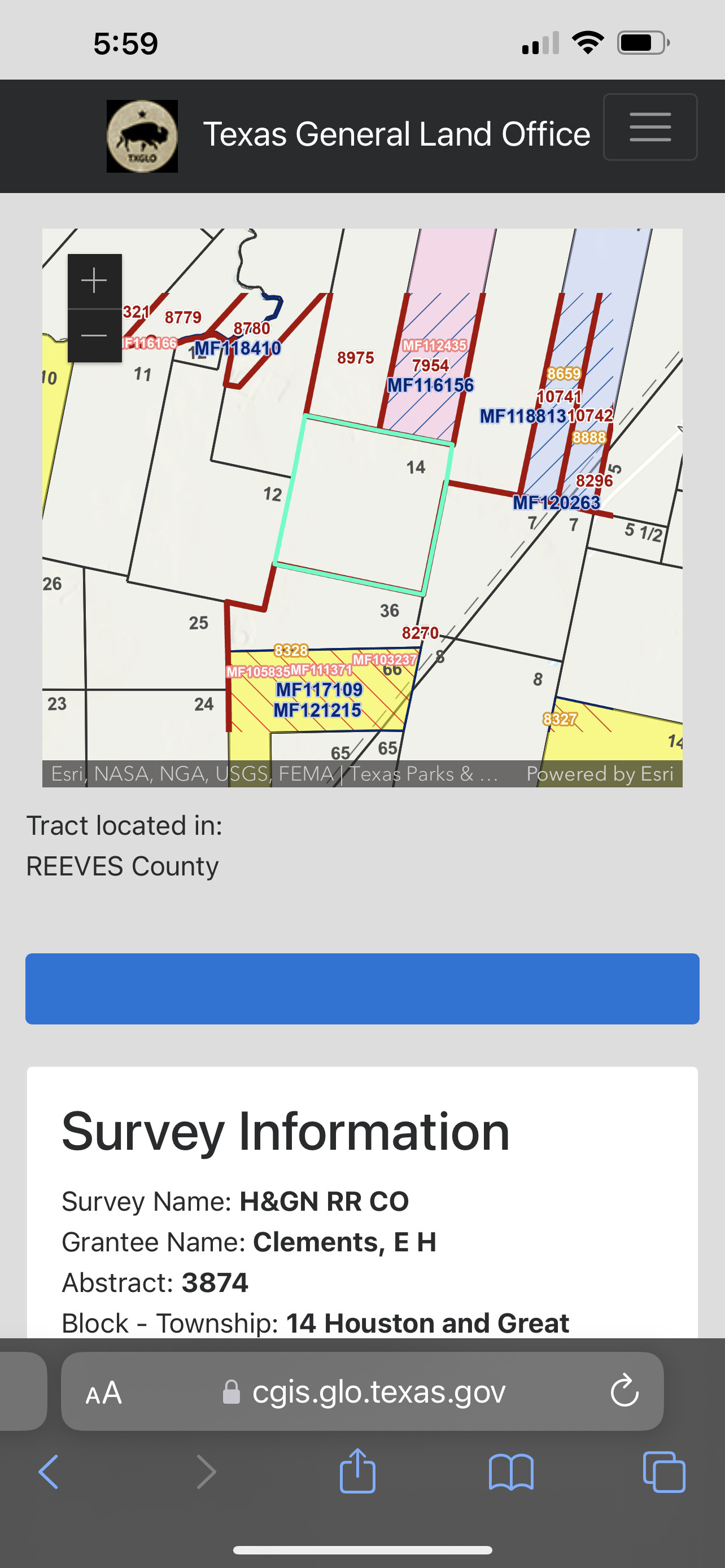
The survey that is designated as Abstract 3874 is the original survey of the full Section 14, and E.H. Clements, that is shown as the alternate name for that survey is the person who was originally patented title to that section by the State. Below is a link to the information page for that survey on the Texas General Land Office website, but I don’t think that is what you are after.
[https://cgis.glo.texas.gov/cfGIS/glomapjs/basefile.cfm?SDENUM=483892001](https://cgis.glo.texas.gov/cfGIS/glomapjs/basefile.cfm?SDENUM=483892001)
---
### Author:  [@marisol1245](https://www.mineralrightsforum.com/u/marisol1245)
#### Post date: [August 8, 2023, 10:01am UTC](https://www.mineralrightsforum.com/t/copy-land-survey/71517/12 "2023-08-08T10:01:34Z")
Hi sorry for the late response and thanks for that information. When looking on the map what are the red and green lines on the map? If I want to sell my land what would be the best way to do that?
---
### Author:  [@system](https://www.mineralrightsforum.com/u/system)
#### Post date: [October 8, 2023, 1:41am UTC](https://www.mineralrightsforum.com/t/copy-land-survey/71517/13 "2023-10-08T01:41:59Z")
This topic was automatically closed after 90 days. New replies are no longer allowed.