# Block location
**URL:** https://www.mineralrightsforum.com/t/block-location/9854
**Category:** Reeves County, TX
**Created:** [July 17, 2014, 10:18pm UTC](https://www.mineralrightsforum.com/t/block-location/9854 "2014-07-17T22:18:06Z")
**Posts on this page:** 20
**Page:** 1
### Author:  [@Barbara\_C\_Mallette](https://www.mineralrightsforum.com/u/Barbara_C_Mallette)
#### Post date: [July 17, 2014, 10:18pm UTC](https://www.mineralrightsforum.com/t/block-location/9854/1 "2014-07-17T22:18:06Z")
I’ve been notified that I am heir to some net mineral acres in Reeves County, Texas, Block 56, PSL Survey, Sections 16, 17, 18, 19, and 20. Can anyone tell me where this is? Is there any activity? Very new to all this.
---
### Author:  [@Craig\_Ronhovde](https://www.mineralrightsforum.com/u/Craig_Ronhovde)
#### Post date: [July 17, 2014, 10:31pm UTC](https://www.mineralrightsforum.com/t/block-location/9854/2 "2014-07-17T22:31:30Z")
Hi Barbara - Welcome to the forum. It will be helpful if you could provide a Township number (1 - 10) or even better would be an abstract number (a four-digit number) for the parcels you have an interest in. There are several Block number 56’s in Reeves County.
---
### Author:  [@Clint\_Liles](https://www.mineralrightsforum.com/u/Clint_Liles)
#### Post date: [July 17, 2014, 10:38pm UTC](https://www.mineralrightsforum.com/t/block-location/9854/3 "2014-07-17T22:38:50Z")
Barbara,
You are in a fantastic area for some future wells. Am posting link to Completion Report of well #389-33803 just to the north of your Section 17:
[http://webapps.rrc.state.tx.us/CMPL/viewPdfReportFormAction.do?method=cmplW2FormPdf&packetSummaryId=88158](http://webapps.rrc.state.tx.us/CMPL/viewPdfReportFormAction.do?method=cmplW2FormPdf&packetSummaryId=88158)
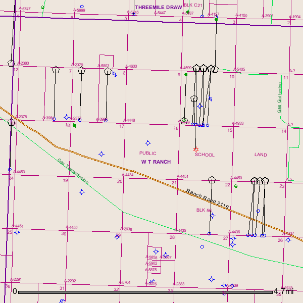
GIS Map of your Sections 16, 17, 18, 19, and 20 in Reeves County Block 56:
---
### Author:  [@Mary\_O\_Wiemann](https://www.mineralrightsforum.com/u/Mary_O_Wiemann)
#### Post date: [July 18, 2014, 12:21am UTC](https://www.mineralrightsforum.com/t/block-location/9854/4 "2014-07-18T00:21:03Z")
Block 56 is NNW of Toyah. You are a fortunate heir indeed.
---
### Author:  [@wade\_caldwell](https://www.mineralrightsforum.com/u/wade_caldwell)
#### Post date: [July 19, 2014, 11:14pm UTC](https://www.mineralrightsforum.com/t/block-location/9854/5 "2014-07-19T23:14:28Z")
Depends on your circumstances, of course, but you should probably be starting at $5000/acre on lease offers.
---
### Author:  [@Barbara\_C\_Mallette](https://www.mineralrightsforum.com/u/Barbara_C_Mallette)
#### Post date: [July 21, 2014, 7:18pm UTC](https://www.mineralrightsforum.com/t/block-location/9854/6 "2014-07-21T19:18:56Z")
Wade Caldwell said:
Depends on your circumstances, of course, but you should probably be starting at $5,000/acre on lease offers.
---
### Author:  [@John\_Everett\_Fine](https://www.mineralrightsforum.com/u/John_Everett_Fine)
#### Post date: [July 21, 2014, 9:07pm UTC](https://www.mineralrightsforum.com/t/block-location/9854/7 "2014-07-21T21:07:33Z")
Barbara, It is in the W T Ranch quad about 20 miles northwest of Pecos. Ranch Road 2119 runs right through the property. There are several horizontal completions to the north and east of your property that run right up to the boundaries. No active wells are shown in the sections, Sec 17 A-4452, Sec 20 A-4455, Sec 19 A-4454, Sec 18 A-4453, Sec 16 A-4434. Yes, a very, very good area.
---
### Author:  [@joseph3](https://www.mineralrightsforum.com/u/joseph3)
#### Post date: [July 23, 2014, 4:14pm UTC](https://www.mineralrightsforum.com/t/block-location/9854/8 "2014-07-23T16:14:20Z")
Clint, any information about Section 16, Block 59 A-4376?
---
### Author:  [@Clint\_Liles](https://www.mineralrightsforum.com/u/Clint_Liles)
#### Post date: [July 23, 2014, 6:36pm UTC](https://www.mineralrightsforum.com/t/block-location/9854/9 "2014-07-23T18:36:01Z")
Joseph,
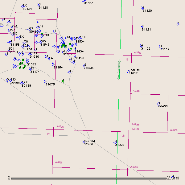
The nearest activity was back in March (spud date March 2014) when API # 389-34062 was spud about a mile to the NE of your A-4376. 11,500’ H well targeting the Wolfcamp formation. No completion report posted.
Link to drilling permit to API # 389-34002:
[http://webapps2.rrc.state.tx.us/EWA/drillingPermitDetailAction.do?methodToCall=searchByUniversalDocNo&universalDocNo=488135609&rrcActionMan=H4sIAAAAAAAAAL1QwWrDMAz9mu5obCcN2UGHMLbz1pb1EHpwE5EanDjIDtvAHz8lY9ClO\_fkp6fnpyclJSXopKQC9UDUVE20ftg11NbyBAv\_gWczjkELbosQTUQRP8UUNllVSlZo2OiX52PFMJthS9Y5O3SvSL2N4W1C-vqxFa1nUQ49xotvD\_7JOMfEFgjjRMPB79FQc2GqBHmTpg5Lt6IuiNGQ6d-Nm3AJyRmy8jHLZTGvwoZn7OwQjjbOZuz2p1Z6VV\_rV2PV\_Y4QfpcvYDQd0tWS\_15Eneq1bg4LKmlQMmUMcpBpy2\_BxO3vu9zzGwTCgfFhAgAA](http://webapps2.rrc.state.tx.us/EWA/drillingPermitDetailAction.do?methodToCall=searchByUniversalDocNo&universalDocNo=488135609&rrcActionMan=H4sIAAAAAAAAAL1QwWrDMAz9mu5obCcN2UGHMLbz1pb1EHpwE5EanDjIDtvAHz8lY9ClO_fkp6fnpyclJSXopKQC9UDUVE20ftg11NbyBAv_gWczjkELbosQTUQRP8UUNllVSlZo2OiX52PFMJthS9Y5O3SvSL2N4W1C-vqxFa1nUQ49xotvD_7JOMfEFgjjRMPB79FQc2GqBHmTpg5Lt6IuiNGQ6d-Nm3AJyRmy8jHLZTGvwoZn7OwQjjbOZuz2p1Z6VV_rV2PV_Y4QfpcvYDQd0tWS_15Eneq1bg4LKmlQMmUMcpBpy2_BxO3vu9zzGwTCgfFhAgAA)
GIS Map of Reeves County A-4376:
---
### Author:  [@Linton\_Tomlin](https://www.mineralrightsforum.com/u/Linton_Tomlin)
#### Post date: [July 24, 2014, 3:27pm UTC](https://www.mineralrightsforum.com/t/block-location/9854/10 "2014-07-24T15:27:08Z")
Barbara, I take pictures of people’s properties in Reeves and Ward Counties for those who want to see the locations. Your tracts are those with red markers. This is from a 1945 map. Linton
(336 KB)
(236 KB)
---
### Author:  [@Tracey\_Hildreth](https://www.mineralrightsforum.com/u/Tracey_Hildreth)
#### Post date: [July 25, 2014, 2:26pm UTC](https://www.mineralrightsforum.com/t/block-location/9854/11 "2014-07-25T14:26:05Z")
Clint do you have pictures of Blk 13 Sec 328, 329, and 320?
---
### Author:  [@Linton\_Tomlin](https://www.mineralrightsforum.com/u/Linton_Tomlin)
#### Post date: [July 25, 2014, 2:34pm UTC](https://www.mineralrightsforum.com/t/block-location/9854/12 "2014-07-25T14:34:39Z")
Barbara, I’m the one that sent you the pictures. Clint sent you the RRC map info. Are you asking for pictures or map? Linton
---
### Author:  [@Tracey\_Hildreth](https://www.mineralrightsforum.com/u/Tracey_Hildreth)
#### Post date: [July 25, 2014, 2:38pm UTC](https://www.mineralrightsforum.com/t/block-location/9854/13 "2014-07-25T14:38:43Z")
Sorry for my confusion, I will take both 🙂 Going to Pecos next week. Would love as much info as possible.
---
### Author:  [@Linton\_Tomlin](https://www.mineralrightsforum.com/u/Linton_Tomlin)
#### Post date: [July 25, 2014, 2:39pm UTC](https://www.mineralrightsforum.com/t/block-location/9854/14 "2014-07-25T14:39:12Z")
Sorry, Barbara, that message was from Tracey, not you! Tracey, did you want actual pictures of where in the county your tracts are? I can do that for you in a few minutes.
---
### Author:  [@Tracey\_Hildreth](https://www.mineralrightsforum.com/u/Tracey_Hildreth)
#### Post date: [July 25, 2014, 2:43pm UTC](https://www.mineralrightsforum.com/t/block-location/9854/15 "2014-07-25T14:43:38Z")
Yes, that would be great!!! THANK YOU!!
---
### Author:  [@Linton\_Tomlin](https://www.mineralrightsforum.com/u/Linton_Tomlin)
#### Post date: [July 25, 2014, 2:58pm UTC](https://www.mineralrightsforum.com/t/block-location/9854/16 "2014-07-25T14:58:12Z")
I was the confused one, Tracey! Here you go, your tracts are the three red markers close together in south Reeves County. Linton
 (347 KB)
 (329 KB)
---
### Author:  [@Tracey\_Hildreth](https://www.mineralrightsforum.com/u/Tracey_Hildreth)
#### Post date: [July 25, 2014, 3:03pm UTC](https://www.mineralrightsforum.com/t/block-location/9854/17 "2014-07-25T15:03:12Z")
Thank you so much!!
---
### Author:  [@Linton\_Tomlin](https://www.mineralrightsforum.com/u/Linton_Tomlin)
#### Post date: [July 25, 2014, 3:08pm UTC](https://www.mineralrightsforum.com/t/block-location/9854/18 "2014-07-25T15:08:13Z")
You’re very welcome. Have fun in Pecos, wish I was going with you. Bet you can find some GOOD cantaloupe!
---
### Author:  [@Clint\_Liles](https://www.mineralrightsforum.com/u/Clint_Liles)
#### Post date: [July 25, 2014, 3:42pm UTC](https://www.mineralrightsforum.com/t/block-location/9854/19 "2014-07-25T15:42:36Z")
Tracey,
Reeves County–Block 13/Section 328/Section 329.
Completion Report on Well # 33561:
[http://webapps.rrc.state.tx.us/CMPL/viewPdfReportFormAction.do?method=cmplW2FormPdf&packetSummaryId=105688](http://webapps.rrc.state.tx.us/CMPL/viewPdfReportFormAction.do?method=cmplW2FormPdf&packetSummaryId=105688)
Well # 33942. No Completion Report found.
Drilling permit for well # 33942:
[http://webapps2.rrc.state.tx.us/EWA/drillingPermitDetailAction.do?methodToCall=searchByUniversalDocNo&universalDocNo=487905643&rrcActionMan=H4sIAAAAAAAAAL1Qu27DMAz8mnQU9HACZ-BgFOncpEEzGBkUm3AEyJZByWgL-ONLuyiQOp0z6Xg8HY8clZSgRyUVqCeiqqiSC92horqUZ5j5D7zYvo9acFvEZBOK9CmGuDJFLlmhYaVfdqeCoZlgTc571zWvSK1LcT8gff3YijqwKIMW0zXUx\_BsvWdiDYRpoO4Y3tBSdWUqB3mXpoxzt6Amit6Sbd-tH3AOyRlMvjVmm02rsOEFG9fFk0uTGbv9qZVe1Lf6xVj1uCPE3-U30NsG6WbJfy-izuVSN4UFNWpQcjQMMpDjmt8NE\_e\_H3LPb\_cd4-RhAgAA](http://webapps2.rrc.state.tx.us/EWA/drillingPermitDetailAction.do?methodToCall=searchByUniversalDocNo&universalDocNo=487905643&rrcActionMan=H4sIAAAAAAAAAL1Qu27DMAz8mnQU9HACZ-BgFOncpEEzGBkUm3AEyJZByWgL-ONLuyiQOp0z6Xg8HY8clZSgRyUVqCeiqqiSC92horqUZ5j5D7zYvo9acFvEZBOK9CmGuDJFLlmhYaVfdqeCoZlgTc571zWvSK1LcT8gff3YijqwKIMW0zXUx_BsvWdiDYRpoO4Y3tBSdWUqB3mXpoxzt6Amit6Sbd-tH3AOyRlMvjVmm02rsOEFG9fFk0uTGbv9qZVe1Lf6xVj1uCPE3-U30NsG6WbJfy-izuVSN4UFNWpQcjQMMpDjmt8NE_e_H3LPb_cd4-RhAgAA)
GIS Map of Reeves County Block 13/Section 328/Section 329:
---
### Author:  [@Tracey\_Hildreth](https://www.mineralrightsforum.com/u/Tracey_Hildreth)
#### Post date: [July 25, 2014, 3:49pm UTC](https://www.mineralrightsforum.com/t/block-location/9854/20 "2014-07-25T15:49:30Z")
You all are awesome! Thank you!
[Next page](https://www.mineralrightsforum.com/t/block-location/9854.md?page=2)