# Block 34 Section 75
**URL:** https://www.mineralrightsforum.com/t/block-34-section-75/53686
**Category:** Ward County, TX
**Created:** [December 4, 2019, 12:13pm UTC](https://www.mineralrightsforum.com/t/block-34-section-75/53686 "2019-12-04T12:13:33Z")
**Posts on this page:** 6
**Page:** 1
### Author:  [@Tony\_Larman](https://www.mineralrightsforum.com/u/Tony_Larman)
#### Post date: [December 4, 2019, 12:13pm UTC](https://www.mineralrightsforum.com/t/block-34-section-75/53686/1 "2019-12-04T12:13:33Z")
Our 3-year lease with CJM Resources will expire next July 2020. I’m curious if anyone knows of anything being done in our Section?
Thanks.
---
### Author:  [@OliverG](https://www.mineralrightsforum.com/u/OliverG)
#### Post date: [December 4, 2019, 4:10pm UTC](https://www.mineralrightsforum.com/t/block-34-section-75/53686/2 "2019-12-04T16:10:35Z")
Jagged Peak drilled and completed two wells that came online in May 2019. The Whiskey River 7374A-34 21H and 11H. Both wells IP’d in the 650 to 700 BOD and 600 to 700 MCFD range.
---
### Author:  [@Tony\_Larman](https://www.mineralrightsforum.com/u/Tony_Larman)
#### Post date: [December 11, 2019, 3:57am UTC](https://www.mineralrightsforum.com/t/block-34-section-75/53686/3 "2019-12-11T03:57:02Z")
Thank you OliverG for your response. I do believe though that the 2 wells you reference are in Section 74 next to us, not in Section 75.
Can someone on the forum confirm this for me please? Thanks.
---
### Author:  [@Clint\_Liles](https://www.mineralrightsforum.com/u/Clint_Liles)
#### Post date: [December 11, 2019, 5:10am UTC](https://www.mineralrightsforum.com/t/block-34-section-75/53686/4 "2019-12-11T05:10:26Z")
Tony the drilling pad to these 2 wells is in Section 73 but the longest part of the horizontal leg is in Section 74.
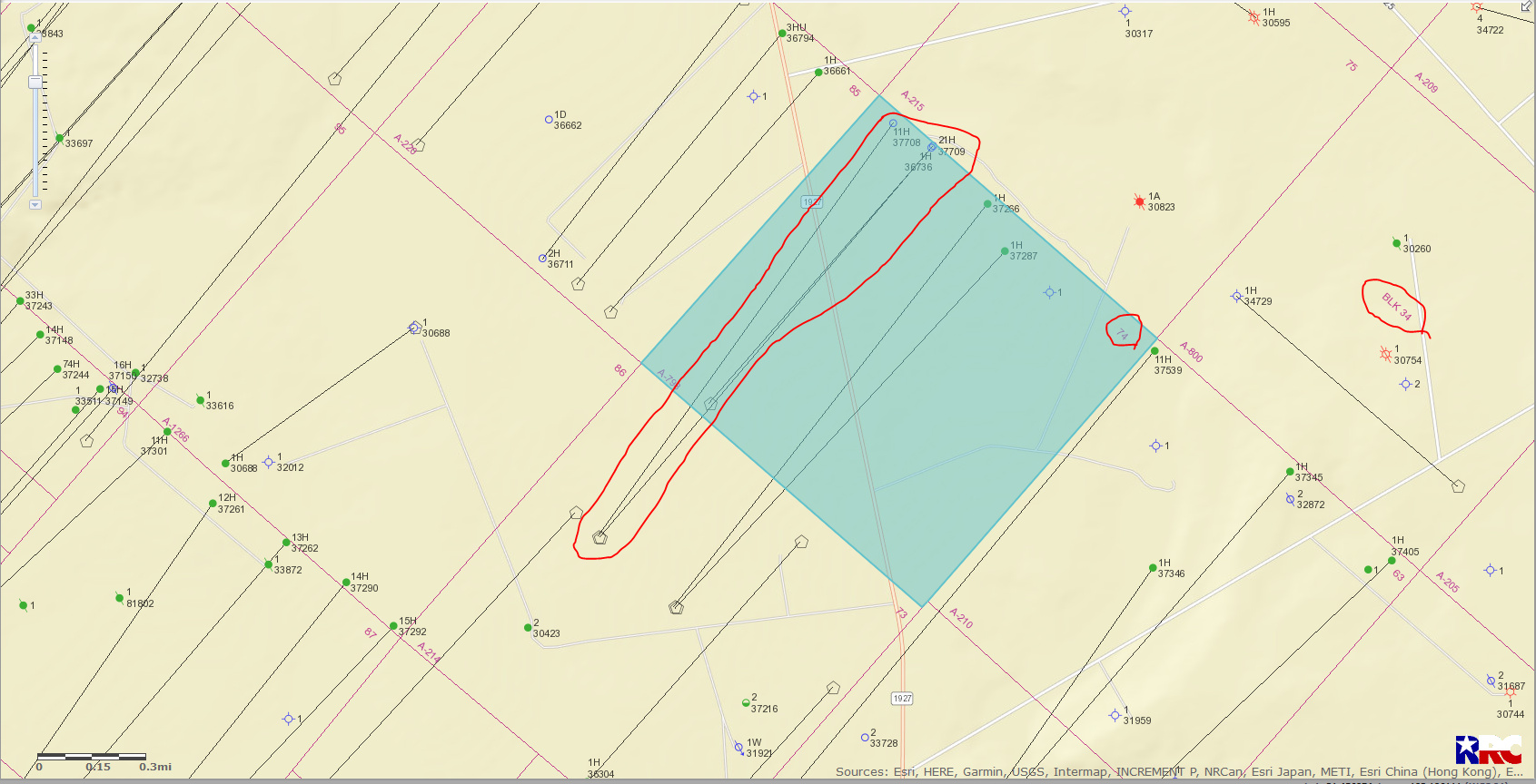
DOUBLE LEFT CLICK ON MAP TO ENLARGE
---
### Author:  [@TwoShoeBeagie7](https://www.mineralrightsforum.com/u/TwoShoeBeagie7)
#### Post date: [December 11, 2019, 3:02pm UTC](https://www.mineralrightsforum.com/t/block-34-section-75/53686/5 "2019-12-11T15:02:52Z")
Which means those wells don’t include Section 75 at all, so the original poster will not benefit from anything other than speculation since Section 75 is contiguous acreage. When zooming out, you see Section 75 is on a very apparent line where horizontals fade to vertical gas wells that fade to extremely old vertical oil wells. In other words, this acreage is on the edge of the play (for now at least) and is all about speculation.
---
### Author:  [@MRFAdmin\_SV](https://www.mineralrightsforum.com/u/MRFAdmin_SV)
#### Post date: [January 11, 2025, 4:52pm UTC](https://www.mineralrightsforum.com/t/block-34-section-75/53686/6 "2025-01-11T16:52:18Z")