# Any oil and gas activity here
**URL:** https://www.mineralrightsforum.com/t/any-oil-and-gas-activity-here/63161
**Category:** Howard County, TX
**Created:** [September 9, 2021, 1:57am UTC](https://www.mineralrightsforum.com/t/any-oil-and-gas-activity-here/63161 "2021-09-09T01:57:55Z")
**Posts on this page:** 9
**Page:** 1
### Author:  [@rudd\_long](https://www.mineralrightsforum.com/u/rudd_long)
#### Post date: [September 9, 2021, 1:57am UTC](https://www.mineralrightsforum.com/t/any-oil-and-gas-activity-here/63161/1 "2021-09-09T01:57:55Z")
NE part of NE/4 Section 1, Blk 35 T1S I hope someone can help me. I am having a very hard time locating this land on the Texas GIS viewer. I have about 5 1/2 acres. It was originally leased by Choate, then Holland Services/Parsley bought them out. I haven’t heard from Holland about a renewal, and I am trying to sort out if there is any activity on this land.
Thanks in advance, Rudd Long
---
### Author:  [@Clint\_Liles](https://www.mineralrightsforum.com/u/Clint_Liles)
#### Post date: [September 9, 2021, 3:33am UTC](https://www.mineralrightsforum.com/t/any-oil-and-gas-activity-here/63161/2 "2021-09-09T03:33:42Z")
rudd, looks as though Block 35 T1S that is in Martin County partially runs over into Howard County. This GIS Map shows the surface without the wells.
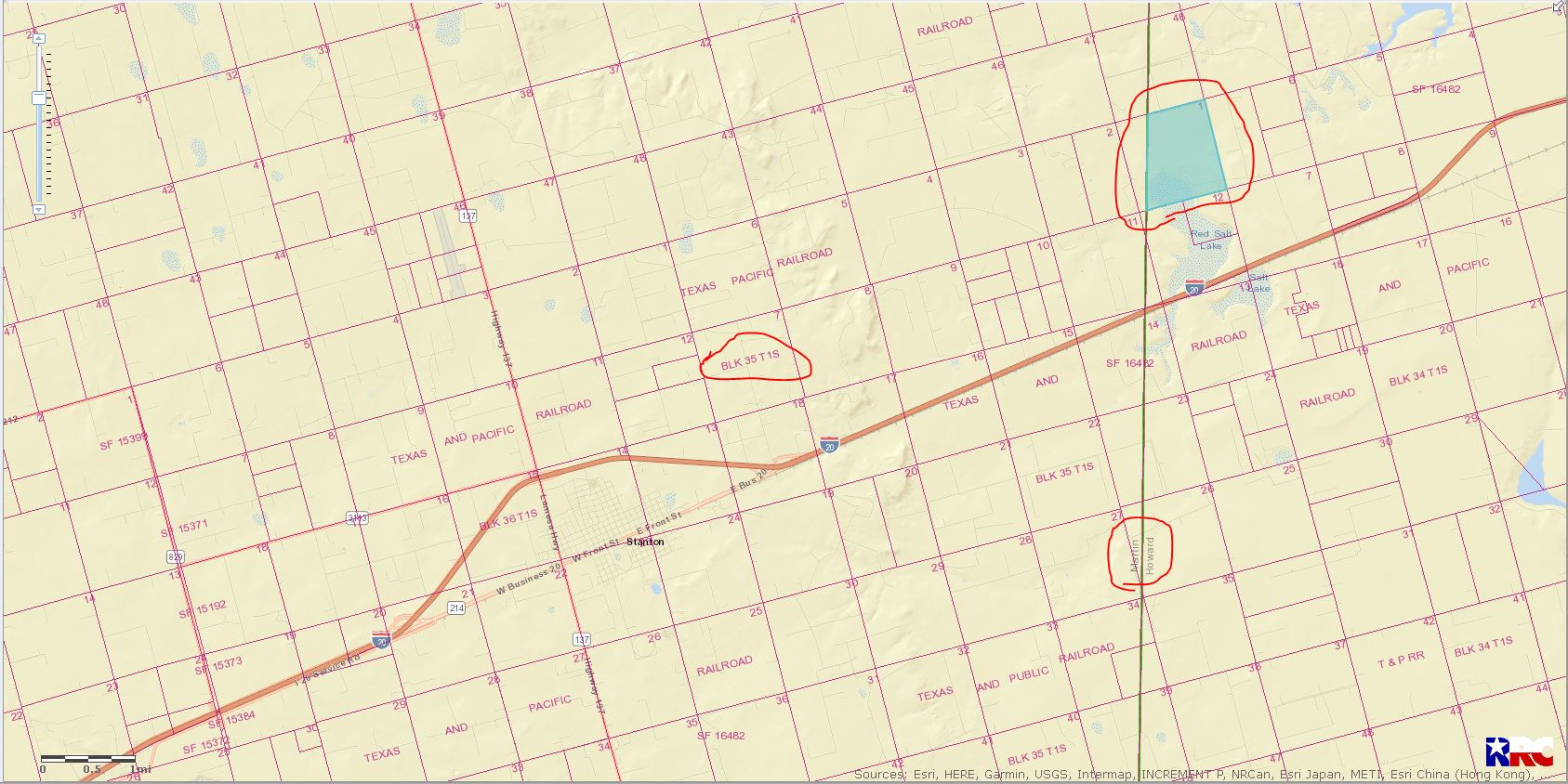
LEFT CLICK ON MAP TO ENLARGE
This GIS Map showing the wells in the area
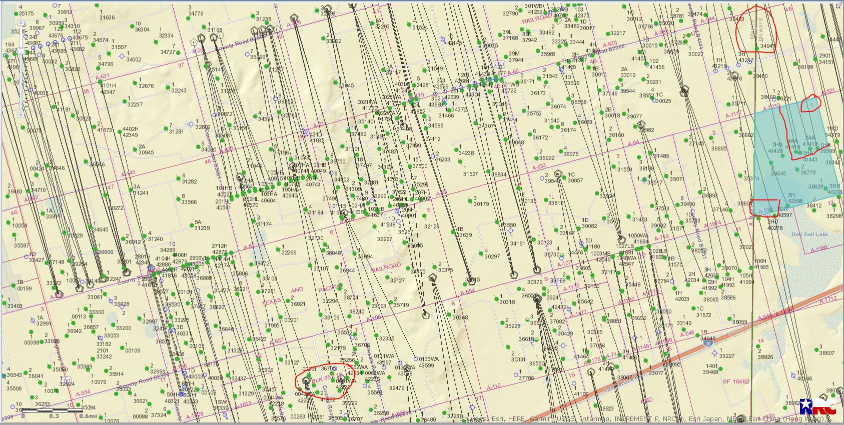
LEFT CLICK ON MAP TO ENLARGE
There are 5 Crownquest Operating wells that end in the Eastern half of Section 1. These wells(227-39599, 41418, 41419, 41420 and 41443) start in Section 37 and end in Section 1. This link is to the approved drilling permit for well 227-39599: [http://webapps2.rrc.state.tx.us/EWA/drillingPermitDetailAction.do?methodToCall=searchByUniversalDocNo&universalDocNo=491712891&rrcActionMan=H4sIAAAAAAAAAL1QwU7DMAz9mnGMknQd68GHCsGZjYkdqh2y1uoipU3lpAKkfDxuEdLoOO-U5-eX52cnJSXopKQC9UBUl3W0vt\_X1FTyBDP\_gWczDEELbosQTUQRP8UYVlm5lazQsNIvz8eSYTbBhqxztm9fkTobw25E-vqxFY1n0Ro6jBffHPyTcY6JHAjjSP3Bv6Gh-sLUFuRNmirM3ZLaIAZDpns3bsQ5JGfQ-jEr8qKYqhzO2No-HG2czNjtT630or7WL8aq-x0h\_C6\_gcG0SFdL\_nsRdaqWuiksqKRByZQxWINMOb8bJm5\_3-We3733IyxhAgAA](http://webapps2.rrc.state.tx.us/EWA/drillingPermitDetailAction.do?methodToCall=searchByUniversalDocNo&universalDocNo=491712891&rrcActionMan=H4sIAAAAAAAAAL1QwU7DMAz9mnGMknQd68GHCsGZjYkdqh2y1uoipU3lpAKkfDxuEdLoOO-U5-eX52cnJSXopKQC9UBUl3W0vt_X1FTyBDP_gWczDEELbosQTUQRP8UYVlm5lazQsNIvz8eSYTbBhqxztm9fkTobw25E-vqxFY1n0Ro6jBffHPyTcY6JHAjjSP3Bv6Gh-sLUFuRNmirM3ZLaIAZDpns3bsQ5JGfQ-jEr8qKYqhzO2No-HG2czNjtT630or7WL8aq-x0h_C6_gcG0SFdL_nsRdaqWuiksqKRByZQxWINMOb8bJm5_3-We3733IyxhAgAA)
All 5 wells are producing from the Spraberry formation. This link is Production Data from well #41443:[http://webapps2.rrc.texas.gov/EWA/specificLeaseQueryAction.do?tab=init&viewType=prodAndTotalDisp&methodToCall=fromGisViewer&pdqSearchArgs.paramValue=](http://webapps2.rrc.texas.gov/EWA/specificLeaseQueryAction.do?tab=init&viewType=prodAndTotalDisp&methodToCall=fromGisViewer&pdqSearchArgs.paramValue=%7C2=07%7C3=2020%7C4=06%7C5=2021%7C103=51666%7C6=O%7C102=08%7C8=specificlease%7C204=district%7C9=dispdetails%7C10=0)
---
### Author:  [@rudd\_long](https://www.mineralrightsforum.com/u/rudd_long)
#### Post date: [September 9, 2021, 7:23pm UTC](https://www.mineralrightsforum.com/t/any-oil-and-gas-activity-here/63161/3 "2021-09-09T19:23:15Z")
thank you very much Clint. It looks like maybe I did not get or mis-laid any notification of the switch from Holland to Crownquest, but I have been getting paid for the Hesperloe wells, I’ll compare pay stub info tonight when I get home to make sure they are the same wells you were kind enough to point out to me.
---
### Author:  [@Clint\_Liles](https://www.mineralrightsforum.com/u/Clint_Liles)
#### Post date: [September 9, 2021, 8:13pm UTC](https://www.mineralrightsforum.com/t/any-oil-and-gas-activity-here/63161/4 "2021-09-09T20:13:28Z")
rudd, some of those wells production is commingled into other lease numbers…if you want the production on the other wells I can post those for you. Clint
---
### Author:  [@rudd\_long](https://www.mineralrightsforum.com/u/rudd_long)
#### Post date: [September 10, 2021, 2:23am UTC](https://www.mineralrightsforum.com/t/any-oil-and-gas-activity-here/63161/5 "2021-09-10T02:23:24Z")
Clint, That might just confuse me further! 😀 I found that the Hesperloe 1HA and 2AA are the only two that cross my interest, at least according to the division order. I originally had 2.77/25 of that 25 acres, but inherited another 2.77/25 in 2015. By my math 5.554/25 gives me a 22.22% interest in that 25 acres, called Tract 7, which is a square in the extreme NE corner of Section 1. My allocation decimal of the two combined is .21083667. Then (I think) we go .2222 \* .21083667 = .0468479. Then .0468479/5 (my fifth from the lease agreement) = .009369
On my exhibit “A” I show .004560310 for one Div. and .004580780 on another. That adds to .00914109 which is spittin distance from what I came up with, .009369.
If I have correctly figured out how this works I will proceed to break my arm patting myself on the back. I’d also be thankful for pointing out if I went wrong
---
### Author:  [@Clint\_Liles](https://www.mineralrightsforum.com/u/Clint_Liles)
#### Post date: [September 10, 2021, 1:25pm UTC](https://www.mineralrightsforum.com/t/any-oil-and-gas-activity-here/63161/6 "2021-09-10T13:25:26Z")
rudd, the production from (API 227-39599/ WRS Hesperaloe 1HA) & (API 227-41418/WRS Hesperaloe 2AA) are commingled into Lease # 51667. This link is to the production data on those 2 wells… [http://webapps2.rrc.texas.gov/EWA/specificLeaseQueryAction.do?tab=init&viewType=prodAndTotalDisp&methodToCall=fromGisViewer&pdqSearchArgs.paramValue=](http://webapps2.rrc.texas.gov/EWA/specificLeaseQueryAction.do?tab=init&viewType=prodAndTotalDisp&methodToCall=fromGisViewer&pdqSearchArgs.paramValue=%7C2=07%7C3=2020%7C4=06%7C5=2021%7C103=51667%7C6=O%7C102=08%7C8=specificlease%7C204=district%7C9=dispdetails%7C10=0)
To find the total production of these 2 wells at the top of the production data page where it says **DATE RANGE** change that begin date to Dec. 2018 and over to the right click **SUBMIT** …there will be 4 pages of production data. Good luck with your wells. Clint
---
### Author:  [@QueenV](https://www.mineralrightsforum.com/u/QueenV)
#### Post date: [September 20, 2021, 2:05am UTC](https://www.mineralrightsforum.com/t/any-oil-and-gas-activity-here/63161/7 "2021-09-20T02:05:11Z")
Clint\_Liles are you aware of any drilling going on in Monahan , Texas?
---
### Author:  [@Clint\_Liles](https://www.mineralrightsforum.com/u/Clint_Liles)
#### Post date: [September 20, 2021, 3:00am UTC](https://www.mineralrightsforum.com/t/any-oil-and-gas-activity-here/63161/8 "2021-09-20T03:00:10Z")
QueenV, this is a list of approved permits for Ward County from January 01, 2021 thru September 17, 2021//////121 approved permits/13 pages. After checking I see no activity around the Monahans area since 2004, 2005, 2006 and that was about 2 miles East of town by Occidental Permian.
[http://webapps2.rrc.state.tx.us/EWA/drillingPermitsQueryAction.do?pager.pageSize=10&pager.offset=0&methodToCall=search&searchArgs.paramValue=](http://webapps2.rrc.state.tx.us/EWA/drillingPermitsQueryAction.do?pager.pageSize=10&pager.offset=0&methodToCall=search&searchArgs.paramValue=%7C1003=08%7C1004=475%7C1005=beginsWith%7C1008=beginsWith%7C1012=beginsWith%7C1015=beginsWith%7C1024=01%2F01%2F2021%7C1025=09%2F17%2F2021&rrcActionMan=H4sIAAAAAAAAAM1Qy07DMBD8mnK0vI7ThsMeIgRnHhU9RD24iZVayktrR4Dkj2cdQIKUM-Ji786OZmcngpSoIkhAuCKqyzq4cXisqankERf8xZ7MNHkleCx8MMGK8Cpmv8nKQjJD4Ubd3R5KLrNUNuS6zg3tvaXeBf8wW3r7kBXNyCSNvQ3nsdmPN6brGMiRbJhp2I9P1lB9ZqhAeeGm8su0pNaLyZDpn00328UkL5ZF-jXqXZ6KHE-2dYM_uJD0WPBHD2rVr_hKowS-ZXmUVJCwHOU1t7D7xFYO4e_y8l85bXEyraVvefwaHhyrNS-ZRR0VgowZAl-oMZMxR8jilsFLhf8W_zv8a0bnuwIAAA)
---
### Author:  [@system](https://www.mineralrightsforum.com/u/system)
#### Post date: [December 8, 2021, 1:58am UTC](https://www.mineralrightsforum.com/t/any-oil-and-gas-activity-here/63161/9 "2021-12-08T01:58:29Z")
This topic was automatically closed after 90 days. New replies are no longer allowed.