# Any activity in 9-24S-29E
**URL:** https://www.mineralrightsforum.com/t/any-activity-in-9-24s-29e/52888
**Category:** Eddy County, NM
**Created:** [November 7, 2019, 1:38pm UTC](https://www.mineralrightsforum.com/t/any-activity-in-9-24s-29e/52888 "2019-11-07T13:38:26Z")
**Posts on this page:** 10
**Page:** 1
### Author:  [@Rph](https://www.mineralrightsforum.com/u/Rph)
#### Post date: [November 7, 2019, 1:38pm UTC](https://www.mineralrightsforum.com/t/any-activity-in-9-24s-29e/52888/1 "2019-11-07T13:38:26Z")
Thanks for any info to assist in sell or keep ORRI.
---
### Author:  [@NMoilboy](https://www.mineralrightsforum.com/u/NMoilboy)
#### Post date: [November 7, 2019, 7:32pm UTC](https://www.mineralrightsforum.com/t/any-activity-in-9-24s-29e/52888/2 "2019-11-07T19:32:11Z")
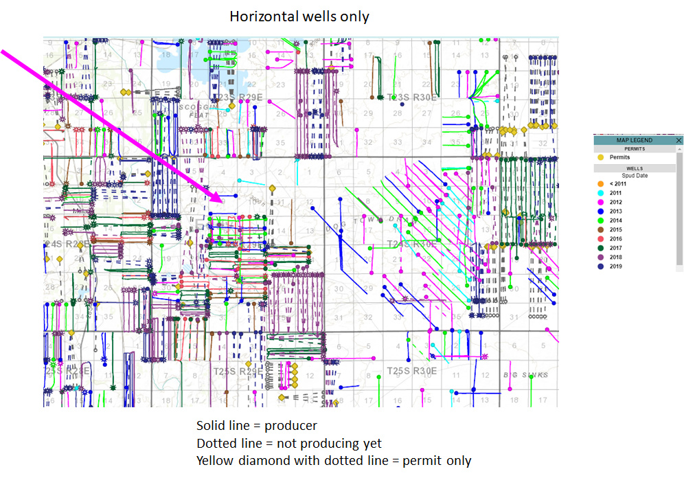
No, there is no obvious current activity in Section 9. It’s in a great zip code, it just looks to be kind of hung up on how Oxy/EOG would develop it. The two older current E-W oriented 2nd Bone Spring wells in Section 9 don’t help you out much as I’m sure people would prefer that Section 9 join with Section 4 to allow for North-South oriented 2 mile laterals.
You don’t have to look very far to find other sections with more than 12 horizontal laterals. Eventually they will figure out how to do that here as well, but for now everyone has a lot of places to drill and things that are difficult are the can that gets kicked down the road.
There are new Devon permits to the East of you and new Oxy permits to the West. Map below has wells colored by spud date.
---
### Author:  [@Rph](https://www.mineralrightsforum.com/u/Rph)
#### Post date: [November 7, 2019, 7:36pm UTC](https://www.mineralrightsforum.com/t/any-activity-in-9-24s-29e/52888/3 "2019-11-07T19:36:56Z")
Many thanks. It does look like 2 producing wells are there.
---
### Author:  [@NMoilboy](https://www.mineralrightsforum.com/u/NMoilboy)
#### Post date: [November 7, 2019, 8:23pm UTC](https://www.mineralrightsforum.com/t/any-activity-in-9-24s-29e/52888/4 "2019-11-07T20:23:58Z")
Yes, there are two older wells in that Section.
Juniper BIP Federal 12H in the N/2 (EOG) 3001540754 Harroun 9 3H in the S/2 (OXY) 3001541488
Online for more than 5 years so you should in theory be getting paid on at least one of those. I’m assuming you own an ORRI in Fed lease NM-099034 which should mean just in the EOG well.
---
### Author:  [@Rph](https://www.mineralrightsforum.com/u/Rph)
#### Post date: [November 7, 2019, 8:43pm UTC](https://www.mineralrightsforum.com/t/any-activity-in-9-24s-29e/52888/5 "2019-11-07T20:43:38Z")
I owe you more than I found doing research. I’ll let you know how it turns out.
---
### Author:  [@Rph](https://www.mineralrightsforum.com/u/Rph)
#### Post date: [February 24, 2020, 4:49pm UTC](https://www.mineralrightsforum.com/t/any-activity-in-9-24s-29e/52888/6 "2020-02-24T16:49:32Z")
NE4, E2NW4, NW4NW4 Section 9 & E2, NW4, 10-24-29. What does this mean?
---
### Author:  [@NMoilboy](https://www.mineralrightsforum.com/u/NMoilboy)
#### Post date: [February 25, 2020, 3:52pm UTC](https://www.mineralrightsforum.com/t/any-activity-in-9-24s-29e/52888/7 "2020-02-25T15:52:41Z")
It means these lands in Township 24S, Range 29E
Section 9:
The Northeast quarter of the section (160 acres) The East half of the NW quarter of the section (80 acres) The NW quarter of the NW quarter of the section (40 acres)
Section 10: The East half of the section (320 acres) The Northwest quarter of the section (160 acres)
---
### Author:  [@Rph](https://www.mineralrightsforum.com/u/Rph)
#### Post date: [February 26, 2020, 7:45pm UTC](https://www.mineralrightsforum.com/t/any-activity-in-9-24s-29e/52888/8 "2020-02-26T19:45:02Z")
Thanks. Do you do NM oil & gas searches for a living or fee?
---
### Author:  [@NMoilboy](https://www.mineralrightsforum.com/u/NMoilboy)
#### Post date: [March 3, 2020, 2:34pm UTC](https://www.mineralrightsforum.com/t/any-activity-in-9-24s-29e/52888/9 "2020-03-03T14:34:57Z")
I have a semi-job looking at NM/TX oil and gas properties. Sometimes I have extra time to look at things. Hasn’t been the case the last 5 weeks, but if you have any questions here I am happy to try to answer them for no fee if I have the time.
---
### Author:  [@MRFAdmin\_SV](https://www.mineralrightsforum.com/u/MRFAdmin_SV)
#### Post date: [January 11, 2025, 6:36pm UTC](https://www.mineralrightsforum.com/t/any-activity-in-9-24s-29e/52888/10 "2025-01-11T18:36:19Z")