# A.M. Davidson Survey A-105
**URL:** https://www.mineralrightsforum.com/t/a-m-davidson-survey-a-105/72786
**Category:** San Augustine County, TX
**Created:** [October 24, 2023, 7:01pm UTC](https://www.mineralrightsforum.com/t/a-m-davidson-survey-a-105/72786 "2023-10-24T19:01:45Z")
**Posts on this page:** 4
**Page:** 1
### Author:  [@Ernest\_Flemons\_Jr](https://www.mineralrightsforum.com/u/Ernest_Flemons_Jr)
#### Post date: [October 24, 2023, 7:01pm UTC](https://www.mineralrightsforum.com/t/a-m-davidson-survey-a-105/72786/1 "2023-10-24T19:01:45Z")
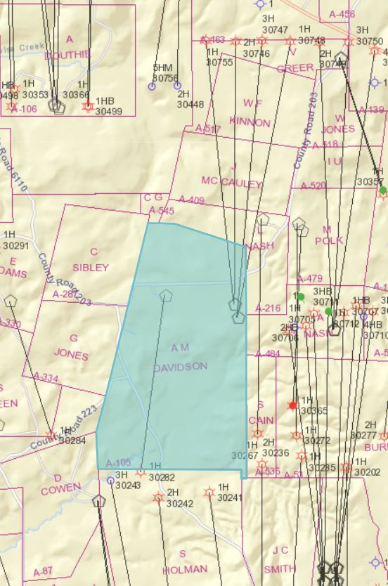
Looking for the map of Survey done by A.M. Davidson A-105.
---
### Author:  [@Dusty1](https://www.mineralrightsforum.com/u/Dusty1)
#### Post date: [October 25, 2023, 4:12pm UTC](https://www.mineralrightsforum.com/t/a-m-davidson-survey-a-105/72786/2 "2023-10-25T16:12:36Z")
Below is the current Railroad Commission map of that area with the survey you ask about highlighted.
Davidson was who Texas originally granted ownership of that survey. If you are wanting to see the original patent here’s a link to it in the General Land Office records. [https://s3.glo.texas.gov/ncu/SCANDOCS/archives\_webfiles/arcmaps/webfiles/landgrants/PDFs/3/5/3/353754.pdf](https://s3.glo.texas.gov/ncu/SCANDOCS/archives_webfiles/arcmaps/webfiles/landgrants/PDFs/3/5/3/353754.pdf)
---
### Author:  [@J\_Walker](https://www.mineralrightsforum.com/u/J_Walker)
#### Post date: [October 25, 2023, 4:12pm UTC](https://www.mineralrightsforum.com/t/a-m-davidson-survey-a-105/72786/3 "2023-10-25T16:12:57Z")
Hi, not sure what information you need but your appraisal district should have maps available, possibly online. If you are looking for well data, the Texas Railroad Commission GIS system can be accessed at [https://www.rrc.state.tx.us/](https://www.rrc.state.tx.us/). You would enter the County name and abstract to zoom to that survey to see well locations.
---
### Author:  [@system](https://www.mineralrightsforum.com/u/system)
#### Post date: [January 22, 2024, 7:02pm UTC](https://www.mineralrightsforum.com/t/a-m-davidson-survey-a-105/72786/4 "2024-01-22T19:02:12Z")
This topic was automatically closed after 90 days. New replies are no longer allowed.